Winter Storm Alert
Meteorologists in the United States are keeping a close eye on a storm that is set to collide with a fresh outbreak of cold air, creating conditions for snow, ice, and slippery travel along the Interstate 5 corridor in Oregon. The potential for dangerous travel conditions extends farther inland and southward, with the possibility of significant snow accumulation.
The region has experienced a challenging week with heavy snowfall and challenging travel conditions through mountain passes, as multiple storms have swept into the Northwest. These storms have not only impacted the Northwest but have also led to blizzard conditions, severe thunderstorms, and flooding rainfall in other parts of the United States.
A cold air mass moving into the area will intersect with the latest storm system from the Pacific through Saturday night. This collision will result in snowfall reaching unusually low levels across much of the Northwest, according to meteorologists.
On Thursday night, Seattle saw cold and moist conditions that allowed for some snowfall. Reports indicated a coating to 1.5 inches of snow to the east and north of the city.
In the coldest areas over northern Washington and Idaho, the dry air in place will likely prevent any snow or ice with the latest storm, despite the cold temperatures. Seattle will remain cold through the weekend, with temperatures 15-25 degrees Fahrenheit below the historical average.
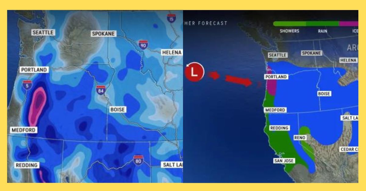
The meteorologists anticipate wintry weather in Portland, Oregon, which has seen little snow so far this month. Cold air draining from the Columbia Gorge into Portland is expected to result in mostly snow and sleet during the height of the storm on Saturday and Saturday night. However, there is concern for a period of freezing rain as well. Accumulations of 1-3 inches of snow and sleet in the city are expected, which is two to six times the historical average for the month.
Travel along the Interstate 5 corridor, from Portland to just north of Medford, Oregon, is likely to become treacherous. The most significant icing impacts are anticipated over Salem, Corvallis, and Eugene.
In the Willamette Valley, the cold air trapped in place while warm air surges overhead may lead to a prolonged period of freezing rain, creating hazardous travel conditions. A potentially significant buildup of ice could result in tree damage and power outages.
The precipitation during the storm is expected to take the form of snow from the Oregon Cascades and California’s Sierra Nevada eastward into southern Idaho, northern Nevada, and Utah. Mountainous areas west and southwest of Bend, Oregon, may experience the highest snow totals of 2-4 feet.
The storm track will lead to accumulating snow even in valley areas that typically don’t see substantial snowfall. Interior areas are expected to receive the heaviest snow on Saturday afternoon into Saturday night, with blizzard conditions possible over southern Idaho.
Cities like Boise, Idaho, and Salt Lake City are already experiencing higher-than-average snowfall this month. Boise, which typically receives 5.3 inches in January, has accumulated 10.3 inches as of January 12. Salt Lake City has received 8.7 inches, surpassing the month-to-date historical average of 4.8 inches.
Following this winter onslaught, a quieter period of weather is expected from Sunday into Monday as high pressure builds in. However, this break may be short-lived, with the possibility of more storminess arriving from the Pacific toward the middle and end of the week. Another storm on Tuesday could bring a zone of ice or a wintry mix to the I-5 corridor from Portland to Seattle.
Additionally, the energy from the storm moving into the Northwest early this weekend may result in snow and ice across the South and East next week. The weather conditions in the coming days will continue to be closely monitored by meteorologists.
Recent Climate – Winter Storm Alert, Winter Storm Alert: Impending Snow and Ice Threatens Northwest, US Winter Storm Alert